Race for Open Space
When is Race for Open Space?
Race for Open Space takes place on Saturday, May 9, 2026 in Carmel-By-The-Sea, CA.
What distances does Race for Open Space offer?
Race for Open Space offers 5 events: Palo Corona to Southbank Trail - Fun Run (1mi), Palo Corona Front-Ranch Lollipop (5k), Palo Corona to Whisler Wilson Overlook - Out & Back (12k), Palo Corona to Williams Canyon - Out & Back (25k), The Lunch Bench Lollipop (35k+).
| Event | Distance | Price | |
|---|---|---|---|
| Palo Corona to Southbank Trail - Fun Run (1mi) | 1.0 mi | $25.00 | Register |
| Palo Corona Front-Ranch Lollipop (5k) | 5.0 km | $50.00 | Register |
| Palo Corona to Whisler Wilson Overlook - Out & Back (12k) | 12.0 km | $75.00 | Register |
| Palo Corona to Williams Canyon - Out & Back (25k) | 25.0 km | $100.00 | Register |
| The Lunch Bench Lollipop (35k+) | 35.0 km | $125.00 | Register |
How much does Race for Open Space cost?
Registration for Race for Open Space starts at $100.00. Prices vary by event distance.
Where is Race for Open Space held?
Race for Open Space is held in Carmel-By-The-Sea, CA at 4860 Carmel Valley Road.
About Race for Open Space
Big Sur Land Trust's 2026 Race for Open Space is a one-day trail running event dedicated to fostering an appreciation of natural spaces in Monterey County and celebrating the health benefits of time spent in nature. This annual event invites runners and hikers of all ages to find wonder among Monterey County’s most iconic landscapes. This time of year will provide participants with sweeping views of green ridge lines punctuated by colorful wildflowers.
Centered around Palo Corona Regional Park, participants are invited to choose their adventure by registering for a 5K, 12K, 25K, or 35K+ trail run. Each course promises a spectacular journey through sections of the Palo Corona Backcountry, normally closed to the public. A one-mile Fun-Run will be offered for individuals of all ages and abilities.
Race for Open Space’s technical partner, Inside Trail Running, will oversee the start/finish line, trail-marking, aid stations, and participant timing/results. All activities will be offered in compliance with public health and safety guidelines. Our community is deeply passionate about our mission to inspire love of land across generations, conservation of our unique Monterey County landscapes, and access to outdoor experiences for all.
On the day of the event, community partners and businesses such as Alvarado Street Brewery will help participants celebrate crossing the finish line with beer, food, and interactive tabling displays.
Accessibility
Visual Disabilities/Course Markings
- Big Sur Land Trust provides trail maps ahead of time on the Race for Open Space website so that participants can familiarize themselves with the general routes available for running and hiking during various events.
- We also use blue, purple, orange, and yellow biodegradable flagging tape to help participants feel confident that they are on the correct course.
- Unfortunately, Big Sur Land Trust is unable to alter this standard course marking to make further visual/non-visual accommodations.
Physical Disabilities
- Individuals with permanent physical disabilities that affect their ability to hike/run will be granted registration but will not be allowed extended time on the course/properties. This is due to safety concerns related to the trails.
- Crutches, braces, poles, and prosthetics may all be used to assist movement.
- Individuals using wheelchairs will be allowed to participate but should note the following areas of concern:
- All terrain is unpaved.
- Courses may include hills with greater than 10% grade; please examine available elevation profiles carefully on the Race for Open Space website.
- Courses may include steep descents that could increase wheelchair speeds greater than 20mph.
- There may be hairpin turns on Race for Open Space courses; please examine available course maps carefully on the Race for Open Space website.
- There are several creek crossings during the 25k and 35k+ courses.
- The use of any motorized device to assist movement will not be allowed.
Guides
- Runners/hikers who need the assistance of a human guide will be granted complimentary registration for their guide. Please contact the Race Director to discuss this in greater detail.
- Guide selection is the participating runner's/hiker's responsibility.
- Tethers may be used for athletes with a visual impairment.
- Runners/hikers with a disability and their guides will follow the same rules as all participants:
- Participating/starting during the timeframe you select during registration. (Please be on time to the event.)
- Running/hiking the course you have registered for, as advertised. (No alteration in trail course will be made.)
Canines
- Dogs are not allowed in beyond the Southbank Trail, into the Palo Corona Regional Park front ranch and backcountry. If you have a visual impairment and require a guide dog, please contact the Race Director for permission to bring your dog to the start/finish of these courses.
FAQ
When does the Race for Open Space take place?
Race for Open Space is a 1-day event that takes place on the second Saturday in May (5/9/26).
What do I get when I register and participate?
A beautiful day on the land! In alignment with our values, we minimize the race swag associated with this event. Participants will receive a physical race bib to help us identify and keep you safe on these courses. Custom posters will be screen-printed at no cost and available to participants, and Alvarado Street Brewery will be pouring a free beer for each participant as well. Big Sur Land Trust merchandise will be available for purchase for those wishing to take home additional keepsakes and further support and promote Big Sur Land Trust.
Access for ALL -
BSLT's commitment to equity If you are interested in participating in the Race for Open Space and aren't able to afford the entry fee AND/OR are part of a BIPOC or LGBTQIA+ community, please reach out to our Race Director. As part of our commitment to 'access for all', we want to help lower barriers to participation in this beloved annual community event.
Can I participate on a bike?
No, this particular event is strictly a run/walk/hike event. (Wheelchair users are permitted to use their chairs, however.) If you are keenly interested in getting out on your bike, we encourage you to check out some of the other organizations and clubs in our region who are putting together great biking events.
How do I get more information about the courses you have?
Hover over "Event Info" in the navigation bar to get a list of the different courses available for this year's event.
Will nutrition or water stations be provided on any of the courses?
Yes! The 12k, 25k, and 35k+ courses will include a limited number of aid stations. An additional hydration station(*not a full aid station) will be provided for the 35k+.There will also be hydration and nutrition available at the start/finish line.
Will restrooms be available along any of the courses?
There are multiple restrooms near the start/finish line. In addition, there is a portalet at the bottom of the hill below Inspiration Point and another at the Williams Canyon Aid Station.
What kinds of hazards should I prepare for during the Race for Open Space?
No matter if on Land Trust courses or running on your own, you should always consider the environment where you will be running and what kinds of things you might run into. For example, if you are running on or near a street, you should always be aware of traffic and wear reflective gear if you are running in the dark.
On all trails, conditions to prepare for include (but are not limited to) poison oak, snakes, thistle, stinging insects, and ticks. We also have terrain that can be muddy or sand-like depending on the weather. The terrain can also be quite uneven and steep. If you own trail running shoes, we recommend wearing those.
Preparing for weather exposure is also important. With the various microclimates in our region, it can be hard to predict what weather conditions you will encounter - you will likely encounter different conditions over the course of the day. It could be very chilly in the morning and could warm up significantly as the day goes on. It could be very foggy, even drizzly, and it could also be a hot, sunny, cloudless day. We recommend preparing yourself for all kinds of weather possibilities, especially by wearing layers and sun protection.
Is there a time limit on any of the courses?
Per our permit, there is a limited time window allowed for the 12k, 25k and 35k+ courses and we must adhere to aid station cut-off times. All participants must be off the course by 3:30 PM.
Will there be photos/videos taken of me at all during the Race for Open Space?
Yes! Our staff and volunteers will be busy capturing special moments on course, and we will share photos with participants after the race.
Are there refunds/rollovers?
Big Sur Land Trust hosts the Race for Open Space as a charitable community engagement event to inspire love of land across generations, conservation of our unique Monterey County landscapes, and access to outdoor experiences for all. We follow standard running industry policy for the Race for Open Space and are not issuing registration refunds except under special circumstances.
If you registered for a Race for Open Space and can no longer make it at that date/time, or if we cancelled that day's outings due to inclement weather, please reach out to the race director Burke Boynton at (831) 224-5241 or bboynton@bigsurlandtrust.org.
I need help with something else!
If you are having issues with registration, please visit this FAQ page first before contacting the Race Director to see if your issue is there: https://help.runsignup.com/support/solutions/17000080452. If your registration issue is not there, or if you have a question about something else, you may leave a message for the Race Director at (831) 224-5241 or bboynton@bigsurlandtrust.org.
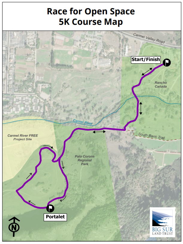
Front Ranch Lollipop - 5k
This course is available for running and walking.
* All courses are subject to route changes. Any changes will be clearly marked by trail flagging.
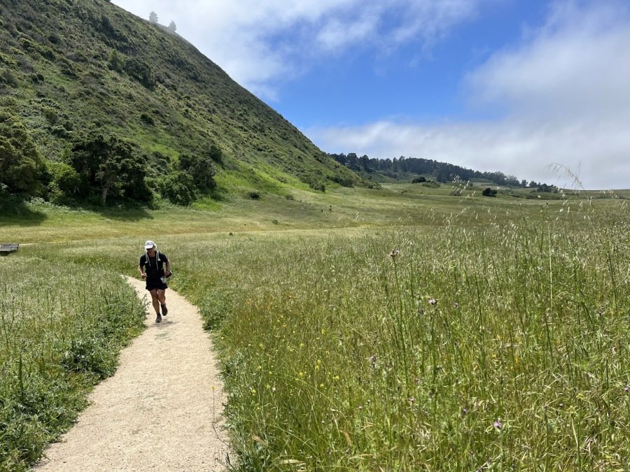
Looking for a fast and fun trail run/walk? This is the option for you! This 5k 'lollipop' course is relatively flat, with just enough elevation change to get your heart pumping and your feet happy!
Our 5k course Start/Finish is at Palo Corona Regional Park Discovery Center, where restrooms and an aid station are available. Runners will follow well-tended trails through Palo Corona's Rancho Cañada, across the Carmel River, and along the much-loved Southbank Trail before entering the Palo Corona Regional Park front ranch (note that dogs are not permitted beyond the Southbank trail). From here, a gentle uphill takes runners to the foot of Inspiration Point (a portalet is available here), as they wrap through the front ranch on its wide and welcoming fire roads. Halfway through the course 'lollipop', runners/walkers are treated to a beautiful view of Big Sur Land Trust's Carmel River Floodplain Restoration and Environmental Enhancement (CR FREE) project site, and the ocean beyond, before completing the lollipop and continuing along familiar trail back to the Start/Finish.
Participants should carry any aid (i.e., water and snacks) they might need while on the course, although a limited-supply aid station will be offered at the Start/Finish. Please note that the Race Team may elect to alter the course or limit the participation of individuals should safety concerns arise due to weather or otherwise.
About Palo Corona Regional Park
Palo Corona Regional Park is one of the Central Coast’s most significant undeveloped open spaces. In the largest land conservation project in Monterey County history, Big Sur Land Trust, the State of California, Monterey Peninsula Regional Park District (MPRPD), and The Nature Conservancy partnered to acquire the 10,000-acre Palo Corona Ranch. The acquisition was finalized in 2004. The 10,000-acre ranch was then divided between the California Department of Fish and Wildlife (CDFW) and MPRPD to be protected in perpetuity. MPRPD created the new Palo Corona Regional Park with the northern 4,350 acres of the former ranch. In 2018, in partnership with The Trust for Public Land, California Wildlife Conservation Board, CDFW, California State Coastal Conservancy, California Natural Resources Agency and Santa Lucia Conservancy, an additional 190 acres of the former Rancho Cañada Golf Course was added to the park.
Beginning at near sea level and rising to over 3,400 feet in elevation, Palo Corona is home to over 500 species of plants as well as several federally-endangered and threatened species including steelhead trout, California red-legged frog, California tiger salamander, Smith’s blue butterfly, golden eagle, and California condor. Palo Corona also provides habitat connectivity for several previously-protected conservation properties, including Garrapata State Park, Joshua Creek Ecological Preserve, Mitteldorf Preserve, Glen Deven Ranch, Point Lobos State Natural Reserve, Santa Lucia Conservancy lands, and the Ventana Wilderness.
About Southbank Trail
Big Sur Land Trust acquired land and multiple trail easements in Carmel Valley to create the Southbank Trail starting in 2011. Located on the south side of the Carmel River, the trail runs between Rancho San Carlos Road and Palo Corona Regional Park. Southbank Trail is maintained by the Monterey Peninsula Regional Park District in agreement with Big Sur Land Trust.
Big Sur Land Trust conserves and cares for the lands you love throughout Monterey County.
Big Sur Land Trust’s conserved properties include diverse habitats that span rare sensitive dunes in Marina, majestic redwood forests in the Santa Lucia Mountains and in Big Sur, expansive oak woodlands, grasslands, and river corridors form Arroyo Seco to the Gabilan Mountains. And in 2017, we added our first urban site at Carr Lake in Salinas! Curious to learn more? Click here for a visual tour of Big Sur Land Trust's protected lands throughout Monterey County.
Course Map
Below is a georeferenced and printable PDF version of this course map. If you use the Avenza app on your phone, you can upload this map to display your GPS location on the course.
Fun Run! 1 Mile - Palo Corona to Southbank Trail

This course is open to runners, hikers, walker, dogs, and strollers!
*All courses are subject to route changes. Any changes will be clearly marked by trail flagging.
For kids, families, or people who want to get out on a shorter course while supporting Big Sur Land Trust, this is the option for you! This 1-mile out-and-back course provides a relatively flat, partially paved option surrounded by the rolling hills of Carmel Valley that is accessible to people of all ages and abilities. The trailhead begins at Palo Corona Regional Park Discovery Center, with portalets and an aid station available on site.
It is expected that participants will carry their own aid (i.e., water and snacks) while on the course, although a limited-supply aid station will be offered at the Start/Finish. The Race Team may elect to alter the course or limit the participation of individuals should safety concerns arise due to weather or otherwise.
About Palo Corona Regional Park
Palo Corona Regional Park is one of the Central Coast’s most significant undeveloped open spaces. In the largest land conservation project in Monterey County history, Big Sur Land Trust, the State of California, Monterey Peninsula Regional Park District (MPRPD), and The Nature Conservancy partnered to acquire the 10,000-acre Palo Corona Ranch. The acquisition was finalized in 2004. The 10,000-acre ranch was then divided between the California Department of Fish and Wildlife (CDFW) and MPRPD to be protected in perpetuity. MPRPD created the new Palo Corona Regional Park with the northern 4,350 acres of the former ranch. In 2018, in partnership with The Trust for Public Land, California Wildlife Conservation Board, CDFW, California State Coastal Conservancy, California Natural Resources Agency and Santa Lucia Conservancy, an additional 190 acres of the former Rancho Cañada Golf Course was added to the park.
Beginning at near sea level and rising to over 3,400 feet in elevation, Palo Corona is home to over 500 species of plants as well as several federally-endangered and threatened species including steelhead trout, California red-legged frog, California tiger salamander, Smith’s blue butterfly, golden eagle, and California condor. Palo Corona also provides habitat connectivity for several previously-protected conservation properties, including Garrapata State Park, Joshua Creek Ecological Preserve, Mitteldorf Preserve, Glen Deven Ranch, Point Lobos State Natural Reserve, Santa Lucia Conservancy lands, and the Ventana Wilderness.
About Southbank Trail
Big Sur Land Trust acquired land and multiple trail easements in Carmel Valley to create the Southbank Trail starting in 2011. Located on the south side of the Carmel River, the trail runs between Rancho San Carlos Road and Palo Corona Regional Park. Southbank Trail is maintained by the Monterey Peninsula Regional Park District in agreement with Big Sur Land Trust.
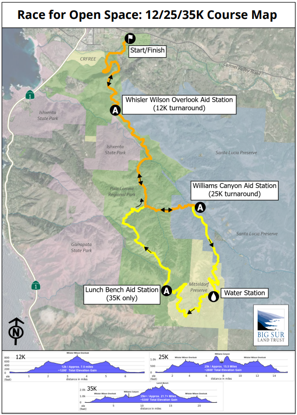
Lunch Bench Lollipop - 35k+
This is a very challenging course, with over 5300’ of total ascent (4400’ of ascent in the first 14 miles), open to runners only. Please see the Whisler Wilson Overlook – 12k Out-and-Back if you are interested in a course to hike. Please see the Williams Canyon – 25k Out-and-Back if you would like a gentler, but still challenging, course to run.
* All courses are subject to route changes. Any changes will be clearly marked by trail flagging.
* Cut-off times: 9:05AM at Whisler Wilson Aid Station and 10:35AM at Williams Canyon Aid Station. If a participant arrives after the designated cut-off time, they will be asked to turn back. Please respect these times as they help us keep everyone safe and allow us to stay within the bounds of our permit.
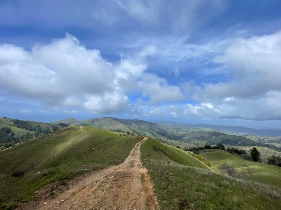
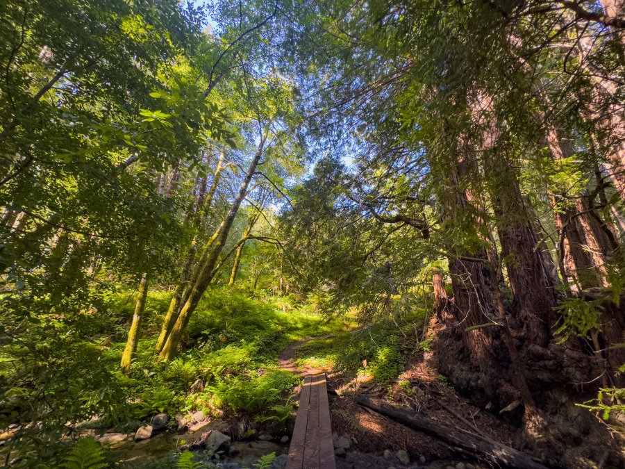
This lollipop course is a serene tour through the backcountry of Palo Corona Regional Park and along a sweeping arc around Big Sur Land Trust’s Mitteldorf Preserve. Runners will enjoy a section of Southbank Trail before starting the climb that will take them past Inspiration Point and Animus Pond to Whisler Wilson Overlook. At Whisler Wilson Overlook they will be rewarded for their efforts by stunning panoramic views of Point Lobos, Carmel River Beach, and the Monterey Peninsula. Runners will then descend to their first creek crossing (San Jose Creek, followed quickly by Seneca Creek) and continue under redwood canopy along fern-lined Seneca Creek, to the beautiful Corona Cabin meadow. From there, it is a little over mile (and a few more creek crossings: Seneca Creek and then San Jose Creek again) to the aid station at Williams Canyon, gateway to Big Sur Land Trust’s Mitteldorf Preserve.
Leaving the Williams Canyon aid station, runners will enjoy a gentle ascent up Wiliams Canyon, running alongside Williams Canyon Creek and passing over the creek via nine of MItteldorf Preserve’s ten historical logging bridges. Instead of crossing the tenth and final bridge, runners will instead begin the climb out of Williams Canyon, winding up to and along Williams Canyon’s rolling rim – hopefully turning looking around often to enjoy sweeping views of Williams Canyon and Carmel Valley. Runners will not quite complete the full tour of the rim, as they turn into Palo Corona Regional Park and make the ascent up to the Lunch Bench, with its incredible views of Monterey Bay, the Pacific Ocean, Carmel Valley, and beyond. With a lot of hard work behind you – 4400’ of ascent 14 miles – we invite runners to enjoy the view as they refuel at the Lunch Bench Aid Station.
After refueling and rehydrating at Lunch Bench, runners will descend along a rolling ridgeline, continuing to enjoy dramatic 365-degree views. A final descent off the ridge takes runners back to the Corona Cabin area; from there, they will continue back to Whisler Wilson Overlook and on to the finish.
This course boasts a total ~5,300 feet of elevation gain and includes some steep ascents and descents. These lands are accessible to the public by guided hike only, so this is a unique opportunity to explore these conserved areas.
Participants are encouraged to carry any aid (i.e., water and snacks) they might need while on the course, although hydration and nourishment will be offered at the Whisler Wilson Aid Station, the Williams Canyon Aid Station, Headwaters Hydration Station (no food), the Lunch Bench Aid Station and (on a limited basis) the Start/Finish. Please note that the Race Team may elect to alter the course or limit the participation of individuals should safety concerns arise due to weather or otherwise.
Palo Corona Regional Park
Palo Corona Regional Park is one of the Central Coast’s most significant undeveloped open spaces. In the largest land conservation project in Monterey County history, Big Sur Land Trust, the State of California, Monterey Peninsula Regional Park District (MPRPD), and The Nature Conservancy partnered to acquire the 10,000-acre Palo Corona Ranch. The acquisition was finalized in 2004. The 10,000-acre ranch was then divided between the California Department of Fish and Wildlife (CDFW) and MPRPD to be protected in perpetuity. MPRPD created the new Palo Corona Regional Park with the northern 4,350 acres of the former ranch. In 2018, in partnership with The Trust for Public Land, California Wildlife Conservation Board, CDFW, California State Coastal Conservancy, California Natural Resources Agency and Santa Lucia Conservancy, an additional 190 acres of the former Rancho Cañada Golf Course was added to the park.
Beginning at near sea level and rising to over 3,400 feet in elevation, Palo Corona is home to over 500 species of plants as well as several federally-endangered and threatened species including steelhead trout, California red-legged frog, California tiger salamander, Smith’s blue butterfly, golden eagle, and California condor. Palo Corona also provides habitat connectivity for several previously-protected conservation properties, including Garrapata State Park, Joshua Creek Ecological Preserve, Mitteldorf Preserve, Glen Deven Ranch, Point Lobos State Natural Reserve, Santa Lucia Conservancy lands, and the Ventana Wilderness.
Southbank Trail
Big Sur Land Trust acquired land and multiple trail easements in Carmel Valley to create the Southbank Trail starting in 2011. This 1.5-mile long pedestrian and bicycle path is located on the south side of the Carmel River between Quail Lodge and Palo Corona Regional Park. Big Sur Land Trust still owns the land and holds the trail easements. The trail is maintained by the Monterey Peninsula Regional Park District.
Whisler-Wilson Ranch
The property known formerly as the Whisler-Wilson Ranch is a 317-acre parcel that belonged to descendants of the A.M. Allan family. Mr. Allan is credited with originally saving Point Lobos from development in the late 1800s. It is located south of Carmel and inland of Highway One, across from Monastery Beach and Point Lobos State Natural Reserve. Big Sur Land Trust acquired the property from the Whisler and Wilson Family Trusts in 2010 and transferred the entire property to the Monterey Peninsula Regional Park District in 2015 as an addition to Palo Corona Regional Park. The property offers stunning “top of the world” views of Point Lobos State Natural Reserve, Carmel River State Beach, and the Monterey Bay National Marine Sanctuary as well as inland views of Palo Corona Regional Park, Jacks Peak, Carmel Valley and the mountain ranges beyond.
Mitteldorf Preserve
Located in the Santa Lucia Mountains southeast of Carmel and home to Monterey County’s largest and oldest known redwood tree, this amazing landscape was forever protected from industrial logging when Harriet and Arthur Mitteldorf provided funds for Big Sur Land Trust to purchase the property in 1990. Over 1,000 acres of riparian habitat, redwood forest, oak woodlands, chaparral, grasslands, and a rare stand of madrone contribute to the beauty of this important watershed and habitat for several protected species. Additionally, this property serves as an emergency access corridor for the adjacent neighbors. Featuring historic structures, this property is one of our six key preserves, where we offer managed public access through hikes, events, and outdoor youth programming.
Big Sur Land Trust conserves and cares for the lands you love throughout Monterey County.
Big Sur Land Trust’s conserved properties include diverse habitats that span rare sensitive dunes in Marina, majestic redwood forests in the Santa Lucia Mountains and in Big Sur, expansive oak woodlands, grasslands, and river corridors form Arroyo Seco to the Gabilan Mountains. And in 2017, we added our first urban site at Carr Lake in Salinas! Curious to learn more? Click here for a visual tour of Big Sur Land Trust's protected lands throughout Monterey County.
Course Map
Below is a georeferenced and printable PDF version of this course map. If you use the Avenza app on your phone, you can upload this map to display your GPS location on the course.
Trails to Explore
Monterey County's iconic vistas and system of protected lands make it a marvelous place to live, and more so if you like hiking or running on trails! During the trail mile challenge for this year's Race for Open Space, why not explore a new trail or two? We asked community members and Big Sur Land Trust volunteers what their favorite public lands to run are in Monterey County so that you can get out and find your wonder across the county.
Note: Please follow county and state COVID-19 guidelines in terms of social distancing and masking. Run at your own risk, be mindful of potentially poor trail conditions, and note potential trail closures on any of these lands. Be especially mindful to stay off muddy trails or trails you suspect will be impacted by any recent rainfall in order to protect these lands and the habitats they contain.
Carmel and Carmel Valley
1. Garland Ranch Regional Park
Big Sur Land Trust acquired and transferred this gem of a property in Carmel Valley to Monterey Peninsula Regional Park District so that the public can access all that it has to offer. From majestic views to diverse flora and fauna, this hilly park is a local favorite for runners and hikers alike. It is also home to the Kiwanis annual Carmel Valley Fiesta - Mountain Run, which traditionally offers 2.25-mile and 7.7-mile options. You can click that link for more information and a basic course map. Volunteer and Wednesday Night Laundry Runner club president Emily Cole also scouted out a couple of other lengths (3.1 and 6.1) for you to explore. Note that some of the trails here are quite steep, and expect ~300-600 feet of elevation gain if you check out Emily's routes. Click for Google directions.
2. Southbank Trail
Owned by Big Sur Land Trust and maintained by Monterey Peninsula Regional Park District, this paved trail is very popular among locals looking for a gentle, nearly-flat place to take a walk among trees and fields. The Carmel Valley Athletic Club traditionally hosts their annual Turkey Trot 5K on this out-and-back trail. If you find yourself just shy of 5K on the trail, doing a loop around the grassy field will help complete your goal--or continue onward past the end of South Bank Trail to run around the front country of Palo Corona Regional Park. Click for Google directions.
3. Palo Corona Regional Park
The nearly 4,500-acre Palo Corona Regional Park is owned by the Monterey Peninsula Regional Park District and its conservation was made possible through the efforts of the Park District, Big Sur Land Trust, The Nature Conservancy, and the State of California (through several of its agencies). It provides habitat connection to 9 previously-protected conservation properties: Garrapata State Park, Joshua Creek Ecological Preserve, Mitteldorf Preserve, Glen Deven Ranch, Point Lobos State Reserve, Santa Lucia Conservancy lands, and the Ventana Wilderness. It also lies adjacent to Big Sur Land Trust's Carmel River FREE project site. The park is broken up into front-country and back-country hiking trails. No permit is required to access the 3+ miles of front-country trails by entering through Rancho Cañada or by walking/biking to the South Bank Trail entrance. Click for Google directions to the Rancho Canada entrance and click here for a trail map.
4. Mission Trail
The Mission Trail Nature Preserve is a 34-acre park owned by the City of Carmel-By-The-Sea. It contains 3 miles of dirt trails, a native plant garden, and various habitats including a Monterey pine forest, coast live oak woodland, wetland, willow riparian corridor and a coastal prairie. The Preserve was designed as a nature park in 1979 for passive recreational use, including dog walking. Click for Google directions; there are a few different trailheads to pick from.
South Carmel/Big Sur
5. Garrapata State Park
Garrapata State Park, a 2,939 acre state park established in 1979, consists of two miles of beach front, featuring coastal hiking and views of the Monterey Bay National Marine Sanctuary. Diverse coastal vegetation, from ocean beaches to dense redwood groves, are accessible through coastal trails. Access to Soberanes Canyon Trail is available from the main trailhead on the east side of Highway 1. Wildlife sightings include sea lions, harbor seals and sea otters, as well as California grey whales during their yearly migration. Click for Google directions.
6. Point Lobos State Natural Reserve
The Point Lobos State Natural Reserve offers opportunities for sightseeing, picnicking, jogging, and more! The Reserve boasts headlands, coves, and rolling meadows as part of the landscape, as well as rare plant communities, endangered archeological sites, unique geological formations, and rich flora and fauna. Just offshore is the Monterey Bay National Marine Sanctuary, where seals, sea lions, sea otters, and migratory grey whales are often spotted. The North Shore Trail offers views of Cypress Cove, Big Dome Cove and Bluefish Cove from the coastline and the Whaler’s Knot Trail offers a hillside view of the surrounding area. If you’re looking for easily accessible ocean views, Sea Lion Point Trail is one to check out! Click for Google directions.
7. Andrew Molera State Park
Andrew Molera State Park offers views of the Monterey Bay National Marine Sanctuary, with miles of trails that wind through meadows, bluffs, beaches, and hilltops. The park is located at the mouth of the Big Sur River and was part of the Rancho El Sur land grant; during your visit, please respect El Sur Ranch signs as these mark where active cattle grazing occurs. The Ventana Wildlife Society has established a Discovery Center within the park that offers exhibits on local wildlife. The Creamery Meadow Trail is a 2-mile roundtrip easy trail that leads to the ocean beach, requiring that you cross the Big Sur River. The Bluffs Trail is 1.7 miles one way and offers a hike along the bluffs, with views of the sandy beach and tides below. Beach access is available at mile 1.7, where the Spring Trail intersects. Click for Google directions.
Fort Ord National Monument - Various Locations
Owned by the Bureau of Land Management, Fort Ord contains more than 86 miles of paved, gravel, and dirt trails--how many of them will you explore during the Race for Open Space? With numerous trailheads, Fort Ord is one of the most accessible places to run if you live on or near the Monterey Peninsula or in Salinas. At "the Ord" you will see a huge diversity of plant life and animals in habitats that include stream side corridors, grasslands, maritime chaparral, oak woodlands and seasonal pools. Read on to learn more about accessing Fort Ord from a variety of trailheads, and click here for a trail map.
8. Creekside Terrace Trailhead: Highway 68 near the Reservation Road/Portola Road Intersection
The Creekside Terrace Trailhead provides access to the east side of the Fort Ord National Monument, with connections to several trails. It is recommended that hikers reference a trail map, here. Following Trail 1 to Trail 41, to Jack’s Rd to Sandy Ridge Rd creates an approximately 5-mile loop with room for exploration on side trails! Click for Google directions. Click for Google directions.
9. Badger Hills Trailhead: Highway 68 across from Toro Place Cafe
Badger Hills Trailhead provides access to the south side of the Ford Ord National Monument, with trail access starting from either Toro Creek Rd or Guidotti Rd. Starting to the left on Guidotti Rd allows hikers to complete a loop, along Skyline Rd and Trail 45, before connecting back to Toro Creek Rd and the Trailhead! It is recommended that hikers reference a trail map. Click for Google Directions.
10. Inter-Garrison/Gigling
After approaching the Inter-Garrison Trailhead, hikers can follow the Jerry Smith Corridor, branching off towards Addington Road, looping back towards the parking lot on on Trails 20, 18, 14, and 52, for an approximately 3.5-mile roundtrip hike. It is recommended that hikers reference a trail map, here. Click here for Google directions to Inter-Garrison Rd Trailhead. Click here for Google directions to Gigling parking.
Monterey/Pacific Grove
11. Veterans Memorial Park
From Veterans Memorial Park, there are a couple of areas you can explore: Huckleberry Hill and Quarry Park Trail. Huckleberry Hill starts near the intersection with Skyline Drive and is well-known for the 185 stairs you must climb before being able to access additional trails. If you're looking to log some big elevation, this is a quick way to do it! Unpaved trails throughout the park offer scenic views of the Monterey coastline. Click here for a basic trail map. Quarry Park Trail starts from the Veterans Park parking lot on the south side and includes a short paved section. The 1.2-mile out-and-back trail passes by some homes before descending into the old quarry, which was dug out to provide rock for the Monterey Breakwater. Click for Google directions to Veterans Memorial Park.
12. Iris Greenbelt
Iris Canyon Road is a low-trafficked paved road adjacent to Monterey Peninsula College and just south of Dennis the Menace park. It is surrounded on both sides by verdant greenery as the canyon traps water from fog and rain. It functions as a connecting route between Monterey and other areas of the Peninsula. Out and back the greenbelt is about 1 mile. You can use the greenbelt, however, as part of a longer run on primarily paved surfaces. North of the greenbelt you can loop around Dennis the Menace Park and connect to the Recreational Trail. South of the greenbelt you can cross under Highway 1 and turn right on Barnet Segal Lane for access to roads leading to Jack's Peak, Pebble Beach, and Carmel. Click for Google directions and watch out for traffic.
13. Monterey Bay Coastal Recreational Trail
Start and end wherever you please along the 18-mile recreational trail, which starts in Pacific Grove and ends as far north as Castroville. Monterey and Pacific Grove's section of this trail are primarily paved, with some unpaved areas in Pacific Grove. The popular trail is mostly flat and hugs the coast, allowing for wildlife sightings likes harbor seals, sea lions, a variety of shorebirds, and sometimes even whales and dolphins. The Wednesday Night Laundry Runners club starts and ends their wintertime runs on this trail in the parking lot across from the Naval Postgraduate School. Click for Google directions.
14. The Rail Trail
This 1.4-mile dirt path (with wood chips in some locations) is actually the Southern Pacific Railroad Right-of-Way and passes through residential neighborhoods on the west side of Pacific Grove. The trail is still owned by Union Pacific and is leased by the City of Pacific Grove for recreation. The trail passes through the Pacific Grove Municipal Golf Course, crosses Lighthouse Boulevard and then runs through forested neighborhoods before crossing Sunset Drive. The final stretch of trail leads to 17 Mile Drive along the Links at Spanish Bay golf course. Click for Google directions (observe the dashed path on the map).
15. Jack's Peak Park
Owned by the County of Monterey, this park provides beautiful views of the Monterey Bay, Peninsula, and Carmel Valley. It contains fossils from the Miocene epoch as well as one of the only remaining natural stands of Monterey Pine trees in the United States. With nearly 8.5 miles of trails for you to explore, you may be tempted to visit this beautiful area more than once during the Race for Open Space. There is a $2 entrance fee for people and dogs alike. Click for Google directions to the entrance and click here for a trail map.
Pebble Beach/Del Monte Forest
16. SFB Morse Botanical Reserve
Created by the Del Monte Forest Conservancy to protect the endangered Gowen Cypress, the Morse Botanical Reserve is a completely forested wonderland in Pebble Beach near Poppy Hills Golf Course. This area is traditionally home to the Pebble Beach Zombie Run and Emergency Preparedness Fair. The trails are all unpaved and mostly fire roads. The structure of these fire roads and trails makes it easy to create a looping route for your run, be it 1 mile, 6 miles, or more. Wintertime can bring muddy and slick conditions in this area, so be prepared for potential slips or to call off a run due to trail conditions for your own safety and to help protect the trail and the surrounding natural resources. Click for Google directions.
Salinas and Surrounding Areas
17. Toro County Park
Located six miles from downtown Salinas, Monterey County first opened Toro County Park to the public in 1971. The park offers 4,756 acres that serve as both habitat for wildlife including deer, coyote, and occasionally a mountain lion or golden eagle, as well as many walkers and outdoor enthusiasts. Several trail running loops exist, ranging from 3 to 8 miles in length, mostly on trails and unpaved roads. Click for a map of Toro County Park. Click for a map of Toro County Park trails.
Whisler Wilson Overlook - 12k Out-and-Back

This course is available for both running and hiking.
This 12k is great for those who wish to have the choice to hike or run! Runners and hikers will enjoy a section of Southbank Trail before starting the climb that will take them past Inspiration Point and Animas Pond to this course's high point (Whisler Wilson Overlook). At Whisler Wilson Overlook they will be rewarded for their efforts by stunning panoramic views of Point Lobos, Carmel River Beach, and the Monterey Peninsula. Whisler Wilson Overlook is accessible to the public by guided hike only, so this is a unique opportunity to visit this beautiful viewpoint.
* All courses are subject to route changes. Any changes will be clearly marked by trail flagging.
This course has an estimated 1,200' of accent, beginning with the climb up to Inspiration Point and continuing to the Whisler Wilson aid station/turn around point.
Participants are encouraged to carry any aid (i.e., water and snacks) they might need while on the course, although hydration and nourishment will be offered at the Whisler Wilson Aid Station and (on a limited basis) the Start/Finish. Please note that the Race Team may elect to alter the course or limit the participation of individuals should safety concerns arise due to weather or otherwise.
Palo Corona Regional Park
Palo Corona Regional Park is one of the Central Coast’s most significant undeveloped open spaces. In the largest land conservation project in Monterey County history, Big Sur Land Trust, the State of California, Monterey Peninsula Regional Park District (MPRPD), and The Nature Conservancy partnered to acquire the 10,000-acre Palo Corona Ranch. The acquisition was finalized in 2004. The 10,000-acre ranch was then divided between the California Department of Fish and Wildlife (CDFW) and MPRPD to be protected in perpetuity. MPRPD created the new Palo Corona Regional Park with the northern 4,350 acres of the former ranch. In 2018, in partnership with The Trust for Public Land, California Wildlife Conservation Board, CDFW, California State Coastal Conservancy, California Natural Resources Agency and Santa Lucia Conservancy, an additional 190 acres of the former Rancho Cañada Golf Course was added to the park.
Beginning at near sea level and rising to over 3,400 feet in elevation, Palo Corona is home to over 500 species of plants as well as several federally-endangered and threatened species including steelhead trout, California red-legged frog, California tiger salamander, Smith’s blue butterfly, golden eagle, and California condor. Palo Corona also provides habitat connectivity for several previously-protected conservation properties, including Garrapata State Park, Joshua Creek Ecological Preserve, Mitteldorf Preserve, Glen Deven Ranch, Point Lobos State Natural Reserve, Santa Lucia Conservancy lands, and the Ventana Wilderness.
Southbank Trail
Big Sur Land Trust acquired land and multiple trail easements in Carmel Valley to create the Southbank Trail starting in 2011. This 1.5-mile long pedestrian and bicycle path is located on the south side of the Carmel River between Quail Lodge and Palo Corona Regional Park. Big Sur Land Trust still owns the land and holds the trail easements. The trail is maintained by the Monterey Peninsula Regional Park District.
Whisler-Wilson Ranch
The property known formerly as the Whisler-Wilson Ranch is a 317-acre parcel that belonged to descendants of the A.M. Allan family. Mr. Allan is credited with originally saving Point Lobos from development in the late 1800s. It is located south of Carmel and inland of Highway One, across from Monastery Beach and Point Lobos State Natural Reserve. Big Sur Land Trust acquired the property from the Whisler and Wilson Family Trusts in 2010 and transferred the entire property to the Monterey Peninsula Regional Park District in 2015 as an addition to Palo Corona Regional Park. The property offers stunning “top of the world” views of Point Lobos State Natural Reserve, Carmel River State Beach, and the Monterey Bay National Marine Sanctuary as well as inland views of Palo Corona Regional Park, Jacks Peak, Carmel Valley and the mountain ranges beyond.
Big Sur Land Trust conserves and cares for the lands you love throughout Monterey County.
Big Sur Land Trust’s conserved properties include diverse habitats that span rare sensitive dunes in Marina, majestic redwood forests in the Santa Lucia Mountains and in Big Sur, expansive oak woodlands, grasslands, and river corridors form Arroyo Seco to the Gabilan Mountains. And in 2017, we added our first urban site at Carr Lake in Salinas! Curious to learn more? Click here for a visual tour of Big Sur Land Trust's protected lands throughout Monterey County.
Course Map
Below is a georeferenced and printable PDF version of this course map. If you use the Avenza app on your phone, you can upload this map to display your GPS location on the course.
Williams Canyon - 25k Out-and-Back
This is a course open to runners only. Please see the Whisler Wilson Overlook – 12k Out-and-Back or the Front Ranch 5k Lollipop if you are interested in a course to hike.
* All courses are subject to route changes. Any changes will be clearly marked by trail flagging.
* Cut-off times: 9:05AM at Whisler Wilson Aid Station. If a participant arrives after the designated cut-off time, they will be asked to turn back. Please respect these times as they help us keep everyone safe and allow us to stay within the bounds of our permit.
This out-and-back race is a serene tour through the backcountry of Palo Corona Regional Park. Runners will enjoy a section of Southbank Trail before starting the climb that will take them past Inspiration Point and Animus Pond to Whisler Wilson Overlook. At Whisler Wilson Overlook they will be rewarded for their efforts by stunning panoramic views of Point Lobos, Carmel River Beach, and the Monterey Peninsula. Runners will then descend to their first creek crossing (San Jose Creek, followed quickly by Seneca Creek) and continue under redwood canopy along fern-lined Seneca Creek, to the beautiful Corona Cabin meadow. From there, it is a little over mile (and a few more creek crossings: Seneca Creek and then San Jose Creek again) to the 25k course turnaround and aid station at Williams Canyon, gateway to Big Sur Land Trust’s Mitteldorf Preserve.
25k participants will be treated to redwood groves, stunning vistas, several creek crossings and much more! This course boasts an estimated 2,800 feet of elevation gain over the 25k and includes some steep ascents and descents. These lands are accessible to the public by guided hike only, so this is a unique opportunity to explore these conserved areas.
Participants are encouraged to carry any aid (i.e., water and snacks) they might need while on the course, although hydration and nourishment will be offered at the Whisler Wilson Aid Station, the Williams Canyon Aid Station and (on a limited basis) the Start/Finish. Please note that the Race Team may elect to alter the course or limit the participation of individuals should safety concerns arise due to weather or otherwise.
Palo Corona Regional Park
Palo Corona Regional Park is one of the Central Coast’s most significant undeveloped open spaces. In the largest land conservation project in Monterey County history, Big Sur Land Trust, the State of California, Monterey Peninsula Regional Park District (MPRPD), and The Nature Conservancy partnered to acquire the 10,000-acre Palo Corona Ranch. The acquisition was finalized in 2004. The 10,000-acre ranch was then divided between the California Department of Fish and Wildlife (CDFW) and MPRPD to be protected in perpetuity. MPRPD created the new Palo Corona Regional Park with the northern 4,350 acres of the former ranch. In 2018, in partnership with The Trust for Public Land, California Wildlife Conservation Board, CDFW, California State Coastal Conservancy, California Natural Resources Agency and Santa Lucia Conservancy, an additional 190 acres of the former Rancho Cañada Golf Course was added to the park.
Beginning at near sea level and rising to over 3,400 feet in elevation, Palo Corona is home to over 500 species of plants as well as several federally-endangered and threatened species including steelhead trout, California red-legged frog, California tiger salamander, Smith’s blue butterfly, golden eagle, and California condor. Palo Corona also provides habitat connectivity for several previously-protected conservation properties, including Garrapata State Park, Joshua Creek Ecological Preserve, Mitteldorf Preserve, Glen Deven Ranch, Point Lobos State Natural Reserve, Santa Lucia Conservancy lands, and the Ventana Wilderness.
Southbank Trail
Big Sur Land Trust acquired land and multiple trail easements in Carmel Valley to create the Southbank Trail starting in 2011. This 1.5-mile long pedestrian and bicycle path is located on the south side of the Carmel River between Quail Lodge and Palo Corona Regional Park. Big Sur Land Trust still owns the land and holds the trail easements. The trail is maintained by the Monterey Peninsula Regional Park District.
Whisler-Wilson Ranch
The property known formerly as the Whisler-Wilson Ranch is a 317-acre parcel that belonged to descendants of the A.M. Allan family. Mr. Allan is credited with originally saving Point Lobos from development in the late 1800s. It is located south of Carmel and inland of Highway One, across from Monastery Beach and Point Lobos State Natural Reserve. Big Sur Land Trust acquired the property from the Whisler and Wilson Family Trusts in 2010 and transferred the entire property to the Monterey Peninsula Regional Park District in 2015 as an addition to Palo Corona Regional Park. The property offers stunning “top of the world” views of Point Lobos State Natural Reserve, Carmel River State Beach, and the Monterey Bay National Marine Sanctuary as well as inland views of Palo Corona Regional Park, Jacks Peak, Carmel Valley and the mountain ranges beyond.
Big Sur Land Trust conserves and cares for the lands you love throughout Monterey County.
Big Sur Land Trust’s conserved properties include diverse habitats that span rare sensitive dunes in Marina, majestic redwood forests in the Santa Lucia Mountains and in Big Sur, expansive oak woodlands, grasslands, and river corridors form Arroyo Seco to the Gabilan Mountains. And in 2017, we added our first urban site at Carr Lake in Salinas! Curious to learn more? Click here for a visual tour of Big Sur Land Trust's protected lands throughout Monterey County.
Course Map
Below is a georeferenced and printable PDF version of this course map. If you use the Avenza app on your phone, you can upload this map to display your GPS location on the course.
About the Race for Open Space
Scroll down for detailed race-day info
Spending time in nature is tremendously important for our well-being. In overwhelming moments of stress, time outdoors can have a calming effect – whether it’s simply stepping into your backyard or a neighborhood park, or, if you’re fortunate enough, heading out to a magnificent open space that’s not too far away from home. Moving in nature helps us find our wonder.
The Race for Open Space is a trail running event that promotes healthy outdoor recreation in connection to local landscapes while raising funds and awareness to support Big Sur Land Trust's work throughout Monterey County. Big Sur Land Trust's mission is to inspire love of land across generations, conservation of our unique Monterey County landscapes, and access to outdoor experiences for all. During this year's Race for Open Space, Big Sur Land Trust encourages you to lace up your shoes, step outside, and race... for open space!
Centered around Palo Corona Regional Park, participants are invited to choose their adventure by registering for a 5k, 12k, 25k, or 35k+ trail run. Each course promises a spectacular journey through sections of the Palo Corona Regional Park (all distances) and Mitteldorf Preserve (35k+ only). A 1-mile Fun-Run will be offered for individuals of all ages and abilities.
Palo Corona Regional Park is one of the Central Coast’s most significant undeveloped open spaces. In the largest land conservation project in Monterey County history, Big Sur Land Trust, the State of California, Monterey Peninsula Regional Park District (MPRPD), and The Nature Conservancy partnered to acquire the 10,000-acre Palo Corona Ranch. The acquisition was finalized in 2004. The 10,000-acre ranch was then divided between the California Department of Fish and Wildlife (CDFW) and MPRPD to be protected in perpetuity. MPRPD created the new Palo Corona Regional Park with the northern 4,350 acres of the former ranch. In 2018, in partnership with The Trust for Public Land, California Wildlife Conservation Board, CDFW, California State Coastal Conservancy, California Natural Resources Agency and Santa Lucia Conservancy, an additional 190 acres of the former Rancho Cañada Golf Course was added to the park.
Beginning at near sea level and rising to over 3,400 feet in elevation, Palo Corona is home to over 500 species of plants as well as several federally endangered and threatened species including steelhead trout, California red-legged frog, California tiger salamander, Smith’s blue butterfly, golden eagle, and California condor. Palo Corona also provides habitat connectivity for several previously protected conservation properties, including Garrapata State Park, Joshua Creek Ecological Preserve, Mitteldorf Preserve, Glen Deven Ranch, Point Lobos State Natural Reserve, Santa Lucia Conservancy lands, and the Ventana Wilderness.
Home to Monterey County’s largest and oldest known redwood tree, the amazing landscape of Mitteldorf Preserve was forever protected from industrial logging when Harriet and Arthur Mitteldorf provided funds for Big Sur Land Trust to purchase the property in 1990. Over 1,000 acres of riparian and oak woodlands, chaparral, grasslands, and a rare stand of madrone contribute to the beauty of this important watershed and habitat for several protected species. Mitteldorf Preserve will be featured in the 35k+ course. Throughout the year, Mitteldorf Preserve is accessible to self-guided hikers by reservation at bigsurlandtrust.org/hike-request.
Big Sur Land Trust, MPRPD, California State Parks, and the Point Lobos Foundation created the Lobos-Corona Parklands (LCP) project by signing a Memorandum of Understanding (MOU) in 2014. Our integrated efforts will benefit the public and promote the preservation of parklands and open space between Carmel and Garrapata State Park. These 10,000+ acres host some of California’s most spectacular coastal areas and vistas, abundant wildlife, diverse habitats and profound historical and cultural resources. The group envisions LCP as the next great parks and conservation landscape in California, while putting a priority on responsible visits and enduring care for the land. Palo Corona and Mitteldorf Preserve are prominent features within the continuous LCP mosaic of conserved lands.
Over its 47-year history, Big Sur Land Trust has helped to conserve over 45,000 acres, including places we love to run and hike, such as Palo Corona Regional Park, Garland Ranch, Mission Trail. Want to learn more? Take a visual tour of Big Sur Land Trust's protected lands throughout Monterey County.
Park/Preserve Information: Palo Corona Regional Park / Mitteldorf Preserve / Lobos Corona Parklands Partnership
Start Times:
35k+ Lunch Bench Lollipop - 8:00 AM
25k Williams Canyon Out-and-Back - 8:00 AM
12k Whisler Wilson Out-and-Back - 8:30 AM
5k Front Ranch Lollipop - 9:00 AM
1-mile Fun Run - 9:00 AM
Check-in and Bib Pickup: Check-in and bib pickup will occur at the start-finish area on race morning: 7:00 – 9:00 AM
Time Limit: There is a 7.5-hour time limit for the 35k+, with a firm 10:35 AM cut-off at the Williams Canyon Aid Station. 35k+ runners who reach the Williams Canyon Aid Station after 10:35 AM will be permitted to continue on the 25k course only. All runners must be off the course by 3:30 PM.
*ALL CUT-OFF TIMES ARE STRICTLY ENFORCED. Please respect the staff and volunteers who are working hard to make this a fun and safe event for all!
Parking: Parking is free and available within the Community Church of the Monterey Peninsula parking lot, adjacent to the Start/Finish area. Please carpool if you can.
Directions:
Community Church of the Monterey Peninsula
4590 Carmel Valley Rd, Carmel-By-The-Sea, CA 93923
Click for directions
Capacity: 1-Mile: 60 | 5k: 80 | 12k: 120 | 25k: 80 | 35k+: 60 (400 total capacity)
Timing: All races are professionally chip timed, utilizing MyLaps and Race Director, ensuring your time is captured as accurately as possible. Disposable chips are attached to back of each bib number.
Post-race: Alvarado Street Brewery will be on-hand, pouring complimentary beer available for race participants 21 years of age or older. The start/finish will also feature the same selection of snacks and drinks as offered at aid stations (see below). We look forward to a start/finish line that is a true community gathering, bringing together many of our wonderful partners, in celebration of open space and our runners!
Dog Policy: Dogs are permitted on the 1-mile Fun Run only and must be on-leash. Dogs are not allowed in the Palo Corona Regional Park backcountry or front ranch. Runners with dogs participating in the 1-mile Fun Run must start at the back of the pack and yield to pup-less runners.
Printable Course Information
Course Map (12k, 25k, 35k+) and Elevations
Course Composition
The courses are largely on non-technical fire roads. The 25k and 35k+ courses include multiple creek crossings. Hiking/trekking poles are allowed on all courses.
Course Markings
Courses are marked with colored surveyor ribbon, placed approximately every 200 meters along the course. Turns are marked heavily on the inside of the turn, with ~3 ribbons placed just before and just after the intersection. There will also be 8.5″ x 11″ laminated signs on the ground (when allowed) at critical or complicated sections. The detailed course map displays which colored ribbons must be followed for each route. Please keep in mind if you are running the 35k+ distance, you will need to follow more than one color while out on the course. The most important course marking is the blue ribbon. Blue ribbons indicate “wrong way” trails. You will see blue ribbons, but do not run past a blue ribbon or you will be heading off course!
*All courses are subject to route changes. Any changes will be clearly marked by trail flagging.
Aid Stations
Inside Trail Racing aid stations are replete with an optimal variety of glycogen-replenishing, electrolyte-replacing products. The following is a list of some of the foods and beverages each aid station may provide: Gu Energy gels and chews, Gu Stroop-Waffles, trail mix, pretzels, potato chips, Oreo cookies, Pop Tarts, PB&J sandwiches, M&M’s, Mike & Ike’s, boiled potatoes with salt, Coke, Mountain Dew, Ginger Ale, water, Skratch Labs Hydration, salt tablets, and seasonal fresh fruit. Aid stations are also equipped with general first aid items (but no anti-inflammatory medicine). Skratch Labs Hydration is mixed so that it contains 180-200 calories per 20 fluid ounces. We encourage runners to carry two 20oz bottles during their run.
Race Medals
As a conservation-minded event, Race for Open Space does not feature race medals. Instead of running for a medal, we invite runners to race for the views, the health benefits… the open space!
Access for ALL BSLT's commitment to equity If you are interested in participating in the Race for Open Space and aren't able to afford the entry fee AND/OR are part of a BIPOC or LGBTQIA+ community, please reach out to our Race Director. As part of our commitment to 'access for all', we want to help lower barriers to participation in this beloved annual community event.
Refund Policy:
Registration is non-refundable and non-transferrable. Only registered runners can participate.
Races may be cancelled or postponed and courses are subject to change due to weather, weather-related impacts, unsafe trail conditions, and other unforeseen events. Runner safety is our top priority, and putting on high-quality race events involves many up-front costs. If a race is cancelled for any reason, registered participants will not receive a refund. If a race is postponed, your registration will be transferred to the new date. We will communicate with all registered runners as soon as possible regarding a course cancellation, course change, or event postponement, and appreciate your support and understanding.